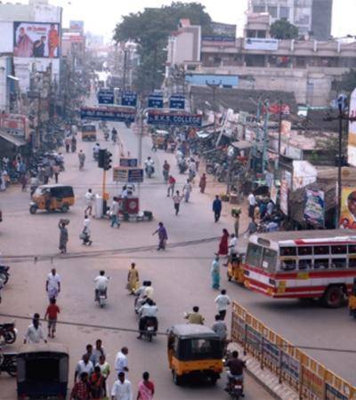
33rd District of Tamil Nadu – Kallakurichi

On January 8, 2019, Hon’ble Chief Minister introduced Kallakurichi District as the 33rd district by bifurcating Viluppuram District on the floor of the Assembly. Later, the new Kallakurichi District was established by G.O.(MS).No.424 and 425 Revenue and Disaster Management Department, Revenue Administration Wing, RA 1(1) Section, Dated:12.11.2019. Following that, on 26.11.2019, the Hon’ble Chief Minister inaugurated Kallakurichi as the 34th district (Tenkasi was inaugurated as the 33rd).
The district is split up into two revenue divisions, each one with six taluks and 562 revenue villages distributed over 24 firkas. The district is divided into 9 development blocks which cover 412 village panchayats. The district headquarters are situated along NH 79 at Kallakurichi (Ulundurpet – Salem). The nearest airports seem to be at Salem, Trichy, and Pondicherry.
The district is primarily agricultural, with key crops including rice, maize, sugarcane, black gramme, and others. The district is primarily rainfed/tank irrigated, with irrigation provided by the Gomukhi and Manimuktha dams.
The district’s main attraction is the Kalvarayan hills, which cover an area of 550.70 square kilometres. Periyar falls, Megham falls, Sirukalur falls, and Chinnathirupathi temple are among the tribal-dominated hills. This district is home to many well-known temples, including Ulagalantha Perumal temple, Veerattaneshwarar temple, and Kabilar hillock in Tirukoilur, Sri Lakshmi Narasimmar temple, Parikkal in Ulundurpet taluk, Adhirangan Ranganathaswamy temple, Thiruvarangam and Arthanareeswarar temple, Rishivandiyam in Sankarapuram taluk.
District Profile
Kallakurichi district is divided into two revenue divisions, six administrative taluks, 562 revenue villages, one municipality, seven town panchayats, nine blocks, and four hundred village panchayats.
| Name of the District : | Kallakurichi |
| District Headquarters : | Kallakurichi |
| Area : | 3530.58 sq.km. |
| Population : | 13,77,494 |
| Revenue Divisions : | Two Revenue Divisions: 1. Kallakurichi 2. Tirukoilur |
| Taluks : | Six Taluks: 1. Kallakurichi. 2. Sankarapuram. 3. Chinnasalem. 4. Kalvarayan Hills. 5. Tirukoilur. 6. Ulundurpet. |
| No. of Firkas : | 24 |
| No. of Revenue Villages : | 562 |
| No. of Village Panchayats : | 412 |
| Assembly Constituencies : | Five Assembly Constituencies: 1. Tirukoilur (Part). 2. Kallakurichi. 3. Sankarapuram. 4. Ulundurpet (Part). 5. Rishivandiyam. |
| Parliamentary Constituencies : | Kallakurichi (Part), Viluppuram (Part) |
| Municipalities : | Kallakurichi |
| Panchayat Unions : | Nine Panchayat Unions: 1. Kallakurichi. 2. Chinnasalem. 3. Rishivandiyam. 5. Sankarapuram. 6. Thiyagadurugam. 7. Kalvarayan Hills. 8. Tirukoilur. 9. Ulundurpet. 10. Thirunavalur. |
| Town Panchayats : | Seven Town Panchayats: 1. Chinnasalem. 2. Vadakkananthal. 3. Sankarapuram. 4. Thiyagadurugam. 5. Ulundurpet. 6. Tirukovilur. 7. Manalurpet. |
| The village far away from the district headquarters : | Varam Village (80 km) in Kalvarayan Hills Taluk. |
| Government Schools : | Primary Schools – 469. Middle Schools – 167. High Schools – 60. Higher Secondary School – 69. |
| Adi Dravidar Welfare School : | Primary Schools – 20. Middle Schools – 05. High Schools – 03. Higher Secondary School – 0. |
| Tribal Welfare School : | Primary Schools – 26. Middle Schools – 13. High Schools – 04. Higher Secondary School – 07. |
| Anganvadis : | 1121 |
| Government Hospitals : | Location of the Government Hospitals: 1. Kallakurichi. 2. Chinnasalem. 3. Sankarapuram. 4. Tirukoilur. 5. Ulundurpet. |
| No. of Primary Health Centres : | 45 |
| No. of Health Sub Centres : | 215 |
| Dispensary : | Thoradipattu (Kalvarayan Hills) |
| Rivers : | Seven Rivers: 1. Gomukhi River. 2. Mani River. 3. Muktha River. 4. Thirumanimuktha River. 5. Mayura River. 6. Kedilam River. 7. Sesha Nathi. |
| Dams : | Two Dams: 1. Gomukhi – 46ft (Height) & 560mcft (Capacity). 2. Manimukhtha – 36ft (Height) & 737mcft (Capacity). |
| Pwd Tanks : | 1. Vellar Basin – 212 Tanks (Capacity: 3514.13mcft & 74 Anicuts). 2. Lower Pennaiyar Basin – 119 Tanks (Capacity: 1778.715mcft & 01Anicuts). |
| Rural Development (Minor Irrigation Tanks): | 359 |
| State Highways : | 312.946 km |
| NHAI : | 1. NH 79 (Salem to Ulundurpet) – 59 km. (V.X-Road to Ulundurpet Roundana). 2. NH 45 (Tambaram to Dindigul) – 35.8km (Madapattu to Vepur Bridge). |
| Major Districts Roads : | 289.150 km |
| Other Districts Roads : | 874.202 km |
| Sugarcane Development Roads : | 118.750 km |
| Food grain production : | 6.25 lakh metric tonne. |
| Horticulture Production : | 3.14 lakh metric tonne. |
| Cattle Population : | 4,14,715 |


